Showing posts with label weather forecast. Show all posts

Sunday, March 15, 2026

Montgomery County under severe storm threat Monday

The latest forecast from the National Weather Service Storm Prediction Center portends trouble for the Washington, D.C. suburbs and central Maryland tomorrow, Monday, March 16, 2026. Many meteorologists are saying the NWS prediction is showing the highest chance of a tornado or derecho event they've seen in many years. The NWS predicts there is a 15-29% chance of a tornado in Montgomery and Frederick Counties Monday. The "moderate" designation means "widespread severe storms are likely," with severe weather most likely between 3:00 PM and 9:00 PM.


Such a forecast underscores the importance of monitoring weather forecasts and NWS bulletins over the next 36 hours. Make sure to bring indoors or secure any objects in your yard or on your balcony that could be lifted by high winds. Replace batteries in flashlights and transistor radios as needed tonight, try to fully charge your cellphone, and ensure you have at least half a tank of gas. A few days' supply of non-refrigerated snacks and water bottles can't hurt. Finally, have a plan for all occupants of your home to quickly move to the basement or lowest level of your house if you receive a Tornado Warning on your phone.


Wednesday, August 7, 2024

When will Tropical Storm Debby impact eastern Montgomery County?


Tropical Storm Debby is currently 471 miles from Montgomery County, Maryland, which will feel the former hurricane's impacts over the next three days. The storm will affect the entire Washington, D.C. metro area from around 8:00 PM Thursday night to 1:00 AM on Saturday morning. Accuweather is currently forecasting a total rainfall of 4 to 8 inches, with peak wind gusts of 40 MPH. The peak of the storm is expected to be from 8:00 AM to 8:00 PM on Friday, when the most rain will fall on the area.

Maryland Gov. Wes Moore

Maryland Gov. Wes Moore has declared a State of Preparedness ahead of the storm. "The safety of Marylanders is our top priority," Moore said in a statement. "By declaring a State of Preparedness, I am directing the Department of Emergency Management to coordinate the comprehensive preparation of State government ahead of potential impacts from the remnants of Tropical Storm Debby. Residents and visitors should monitor local weather forecasts, remain vigilant, and be prepared to follow safety instructions from local emergency officials."

Remember to keep phones and devices charged ahead of the storm. Now is the time to check batteries in your flashlights, and purchase additional batteries. Have a small transistor radio to monitor emergency bulletins and weather conditions if you lose power. And make sure your gas tank is at least half-full.

Tropical Storm Debby is currently approaching the coast of South Carolina. Its maximum sustained wind speed is 60 MPH, according to the National Weather Service, and it is moving northeast at 5 MPH. The storm is blamed for the deaths of six people in the southern United States so far.

Images courtesy NOAA, Office of Gov. Wes Moore

Saturday, September 23, 2023

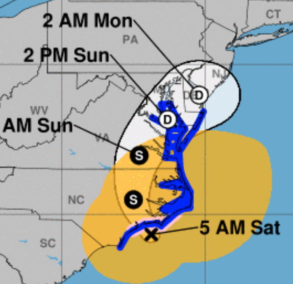
Tropical Storm Ophelia makes landfall, already impacting Maryland/Washington, D.C. area


Tropical Storm Ophelia has made landfall near Emerald Isle, North Carolina, but the outer rain bands of the storm had already entered the Washington, D.C. area overnight. What will the impacts of Ophelia on the eastern Montgomery County area be? The National Weather Service predicts rainfall amounts from 2-4" in the Montgomery County/Washington, D.C. area. High winds with gusts up to 45-55 MPH are also anticipated.

Montgomery County and Washington D.C. are under a National Weather Service-issued Wind Advisory from 8:00 AM to 8:00 PM today. The NWS forecasts northeast winds of 20 to 30 MPH, with gusts up to 55 MPH expected. Gusts up to 50 mph are possible along the immediate shore of the Chesapeake Bay and Tidal Potomac. Ocean City, Maryland is experiencing street flooding and wind gusts up to 50 MPH.Secure any outdoor furniture or objects light enough to blow away, or bring them indoors.

Maryland Governor Wes Moore has
declared a State of Emergency

Maryland Gov. Wes Moore has declared a State of Emergency. "If you can avoid driving or being out during the storm, please do so," Moore said. "We are expecting an extended period of strong winds, heavy rainfall, and elevated tides." Flooding, falling limbs, downed trees and power outages are expected.

Ophelia is currently located 25 miles WNW of Cape Lookout, North Carolina. Its sustained winds measured at Cape Lookout are currently 61 MPH, with gusts up to 73 MPH. The storm is moving NNW at 9 MPH, and will affect the D.C. region through Sunday.

Heavy rainfall and sustained wind gusts will combine for conditions that favor trees falling, causing damage and power outages. Charge cellphones and make sure you have batteries for flashlights and radios.

WMATA reports Metrobus routes D33 Westbound and E4 Westbound are temporarily detouring at Military Road and 14th Street NW, and resuming their routes at Military Road and 16th Street NW, due to weather conditions. Pepco is reporting a few, small power outages in Gaithersburg at this hour.

Tracking map courtesy National Hurricane Center

Sunday, April 9, 2023

Montgomery County issues hypothermia alert


The Montgomery County Office of Emergency Management and Homeland Security has issued a Hypothermia Alert for Monday, April 10, 2023, between the hours of 2:00 AM and 10:00 AM. During that time, the wind chill is forecast to be below 32 degrees. 

A Hypothermia Alert means that conditions present a danger of hypothermia or frostbite to those outdoors for extended periods. Dress warmly and wear layers if you must spend significant time outdoors during the hours covered by the alert. If you have safety concerns about people or pets, you are asked to call 301-279-8000.

Thursday, April 6, 2023

Montgomery County under Severe Thunderstorm Watch until 10 PM


The National Weather Service has issued a Severe Thunderstorm Watch for central and southern Maryland, Northern Virginia, and Washington, D.C., effective until 10:00 PM tonight, April 6, 2023. Violent thunderstorms are expected. Isolated wind gusts up to 70 MPH and large hail are possible. It is currently 85 degrees, but temperatures tonight will plunge into the 40s after the storms pass through the area.

Make sure your phone is charged, and that you have fresh batteries in your flashlight. Keep a battery-powered radio nearby, and retrieve any objects that might be blown around by winds from your yard or balcony.

Thursday, September 29, 2022

Hurricane Ian remnants to impact Montgomery County sooner than expected


The worst of Hurricane Ian may have already passed in Florida, but the now-Tropical Storm is expected to make a speedy trip up the East Coast, including a jaunt out to sea and another landfall somewhere in the South. Yesterday, Ian's timetable for arrival in the Washington, D.C., Maryland and North Virginia area began to look like it was slipping from early next week to this weekend. Now, Accuweather is forecasting the first rains of Ian to arrive in the Mid-Atlantic as early as tomorrow. 

Tropical rain showers are now expected all weekend, and showers may continue from Monday into Wednesday. This does not look good for events like Taste of Bethesda this Saturday. Rain associated with Ian will arrive well ahead of the actual storm center, which is expected to pass through Maryland sometime Sunday night or early Monday morning.

Ian has further business south of here first, however. After crawling across mainland Florida, the storm will go back over the Atlantic, and make another landfall tomorrow evening. Accuweather currently predicts Ian's landfall will be somewhere near the border of Georgia and South Carolina Friday night; the National Hurricane Center's prediction is for a landfall in South Carolina. 

The full impact of Ian's second landfall, and the strength of the storm's remnants when it arrives here in the D.C. area, will be determined by how long it drifts over the waters of the Atlantic prior to Friday night's landfall. The National Hurricane Center says the storm could again near hurricane strength as it approaches land.

Ian already has shown plenty of destructive power after making landfall as a Category 4 hurricane. Over 2 million utility customers in Florida are currently without electricity. Accuweather reports that every customer in Hardee County, Florida is in the dark. Part of the Sanibel Causeway collapsed, the only bridge between Sanibel Island and mainland Florida. 

Florida Gov. Ron DeSantis said earlier this morning that helicopter rescues are being performed on barrier islands by the Coast Guard and Florida National Guard. He said 100 portable cell towers are being set up to restore some level of phone service, and that power line infrastructure in the hardest hit areas would in some cases have to be entirely rebuilt. Pine Island Bridge, like the Sanibel Causeway, is damaged and impassable, he added.

Fox Weather reports that there are believed to be hundreds of fatalities in Lee County, Florida, according to the sheriff there. Accuweather reports one confirmed death in Florida from Hurricane Ian, a 72-year-old man in Deltona. He slipped down a hill behind his home into a flooding drainage ditch while trying to drain his pool as the storm approached his area at 1:00 AM this morning. Fox Weather also reports Ian has caused a 200-year flood event in Orlando. More than a foot of rain has fallen on the city.

DeSantis said his state has all of the supplies it needs for storm victims. "It's much better to donate financially, rather than sending items. We've got a lot of items," he said at a news conference this morning. Those seeking to help storm victims displaced in Florida can have the greatest impact by donating funds at FloridaDisasterFund.org, or text DISASTER to 20222, he said. Florida First Lady Casey DeSantis said the fund has already raised $1.6 million in the last 24 hours.

Tropical Storm Ian's current location is 40 miles east of Orlando, the National Hurricane Center reports. Its current maximum sustained winds are at 65 MPH, and it is moving NE at 8 MPH.

Graphic courtesy Accuweather.com

Wednesday, August 10, 2022

Flood watch in effect for Montgomery County as severe storms approach


Severe thunderstorms are expected to pass through the area this afternoon and evening. The National Weather Service has issued a Flood Watch that will remain in effect until 11:00 PM tonight for Montgomery County, Prince George's County and most of Maryland west of the Chesapeake Bay, Washington, D.C. and Northern Virginia. Rainfall amounts of 2-4" are expected, in timeframes as little as one or two hours, leading to potential flash flooding. Isolated strong wind gusts are also expected.


Maryland Gov. Larry Hogan (R) issued a statement this afternoon regarding the severe weather forecast. "More severe weather is expected to impact our state this afternoon and evening, including thunderstorms that could produce damaging wind gusts, heavy rainfall, and flash flooding," Hogan said. He urged residents to "please monitor local forecasts, exercise caution while traveling, and never drive through standing water."

Now is the time to charge your devices, and check the batteries in your flashlights. Bring objects that might fly away in from yards and balconies. Have a battery-powered radio to receive information in case of power outages. For Pepco customers, download the Pepco app to report power outages.

Thursday, April 7, 2016

Accidents galore as bad weather hits Silver Spring

Several collisions have made the usually-bad commute even worse this morning. Rain moving into the area may have worsened road conditions.

A multi-vehicle collision in Hillandale involving a bus did not result in any injuries, according to Montgomery County Fire and Rescue spokesperson Pete Piringer. That happened at New Hampshire Avenue and Ruppert Road.

Prior to that, 3 victims were transported after an accident at Connecticut Avenue and Weller Road. One of those patients had to be extricated from a vehicle.

And earlier this morning, a pedestrian was struck at Georgia Avenue and Grace Church Road, just outside of downtown Silver Spring.

Allow extra time on the road, as the rain is only expected to worsen by afternoon, when thunderstorms are forecast.

Monday, February 3, 2014

SNOW FORECAST FOR EAST MONTGOMERY COUNTY - SILVER SPRING/WHEATON/BURTONSVILLE

The snow forecast for eastern Montgomery County is insignificant today. Expect a mix of rain and snow between early morning and mid-afternoon. Temperatures are forecast to remain above freezing throughout the day. Clouds will give way to clear skies by 8:00 tonight, but temperatures will drop below freezing - expect them to be in the upper twenties overnight.